Meteorologist Kenneth Svec's www.nnjweather.com
Weather Forecasts for Northern New Jersey, New Jersey, Westwood, Bergen County, Passaic County, Morris County, Hudson County, Union County, Essex County, Warren County and Sussex County by meteorologist Sec
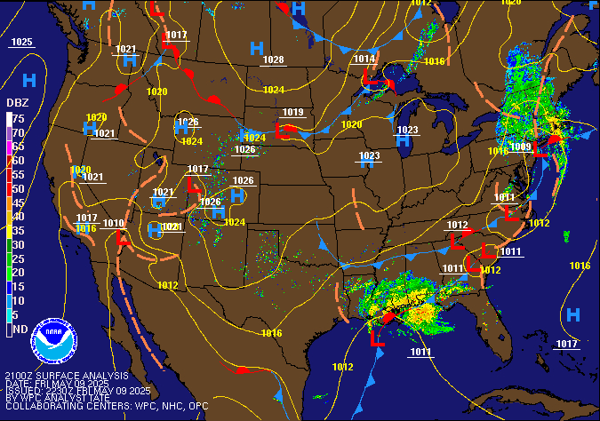
Current Surface Weather Map of the United States

Forecast Explanation Weather radars Local Observations Weather Maps Severe Weather Satellite Maps Weather Links Tropical Weather Winter Weather Allergy Forecasts My political links
For weather updates you can follow me on my twitter page - You
can also contact me on my Facebook page
or
you can email ksvec@aol.com
Sunday February 19th
Partly to mostly cloudy and mild
High 48-52, Low 30-35 .. 25-30 for inland NJ
. ..
Weather Radars Local Observations Weather Maps Severe Weather Satellite Maps Weather Links Tropical Weather Winter Weather Allergy Forecasts
..
The skies will be partly to mostly cloudy today and the temperatures will be mild with highs in the upper 40's and lower 50's for Westwood and most of northern New Jersey. Mostly cloudy skies can be expected for this evening and it will be cool with lows in the low to mid 40's for Westwood and eastern sections of northern New Jersey and lows in the mid to upper 30's for inland sections of northern New Jersey.
Weather Radars Local Observations Weather Maps Severe Weather Satellite Maps Weather Links Tropical Weather Winter Weather Allergy Forecasts
For weather updates you can follow me on my twitter page You
can also contact me on my Facebook page
or you can email
ksvec@aol.com


The weather forecast for
Westwood, Bergen County and northern New Jersey
Today
Partly to mostly cloudy and mild.
High 48-52.
Tonight
Mostly cloudy and cool.
Low 40-45 .. 35-40 for inland sections of NNJ.
Monday
Mostly cloudy and mild with a chance of a shower.
High 53-58
Monday Evening
Mostly cloudy and cold with a chance of a rain or shower.
Low 35-40 ..25-30 for inland sections of NNJ.
Tuesday
Partly sunny an mild. Slight chance of a shower.
High 50-55.
Tuesday Evening .
Becoming cloudy with a chance of a late night shower.
Low 33-38.
Wednesday
Mostly cloudy and mild with a chance of a shower.
High 50-55.
Wednesday Evening .
Cloudy and cold with a chance of a shower,
Low 35-40 .. 30-35. for inland NNJ.
Weather Radars Local Observations Weather Maps Severe Weather Satellite Maps Weather Links Tropical Weather Winter
For weather updates you can follow me on my twitter page - You
can also contact me on my Facebook page
or you can email
ksvec@aol.com
A warm front will approach New Jersey from the west and southwest during the daytime and evening hours today. The daytime skies will be partly to mostly cloudy and the temperatures will be mild with highs in the upper 40's and lower 50's for Westwood and most of northern New Jersey. Mostly cloudy skies can be expected for this evening and it will be cool with lows in the low to mid 40's for Westwood and eastern sections of northern New Jersey and lows in the mid to upper 30's for inland sections of northern New Jersey.
A cold front will move through New Jersey from the west and northwest during the daytime and evening hours tomorrow. The daytime skies will be mostly cloudy with a slight chance of a shower and the temperatures will be mild with highs in the mid 50's for Westwood and most of northern New Jersey. Tomorrow evening will be mostly cloudy with a chance of a rain or snow shower and the lows will be in the mid to upper 30's for Westwood and eastern sections of northern New Jersey and lows in the low to mid 30's for inland sections of northern New Jersey.
A weak cold front will move quickly through New Jersey from the west during the daytime hours on Tuesday then a warm front will begin to approach New Jersey from the south on Tuesday evening. The daytime skies will be partly sunny with a slight chance of a shower and the temperatures will be mild with highs in the low to mid 50's for Westwood and most of northern New Jersey. Clouds will increase on Tuesday evening with a chance of a shower and the lows will be in the mid 30's.
A warm front will move back through New Jersey from the south on Wednesday. The daytime skies will be mostly cloudy with a slight chance of a shower and the temperatures will be mild with highs in the low to mid 50's for Westwood and most of northern New Jersey. Wednesday evening with be mostly cloudy with a chance of a shower and the lows will be in the mid to upper 30's for Westwood and eastern sections of northern New Jersey and lows in the low to mid 30's for inland sections of northern New Jersey.
Weather radars Local Observations Weather Maps Severe Weather Satellite Maps Weather Links Tropical Weather Winter Weather Allergy Forecasts
Extended Forecast
Thursday will be mostly cloudy with a chance of a shower and the highs will be in the lower 50's..
Weather radars Local Observations War Maps Severe Weather Satellite Map-s Weather Links Tropical Weather Winter Weather Allergy Forecasts My political links
For weather updates you can follow me on my twitter page - You
can also contact me on my Facebook page
or you can email
ksvec@aol.com